Click on the links for slideshows of hikes to different lakes. There are only a few for now, but the number should increase bit by bit, as we continue hiking in the park.
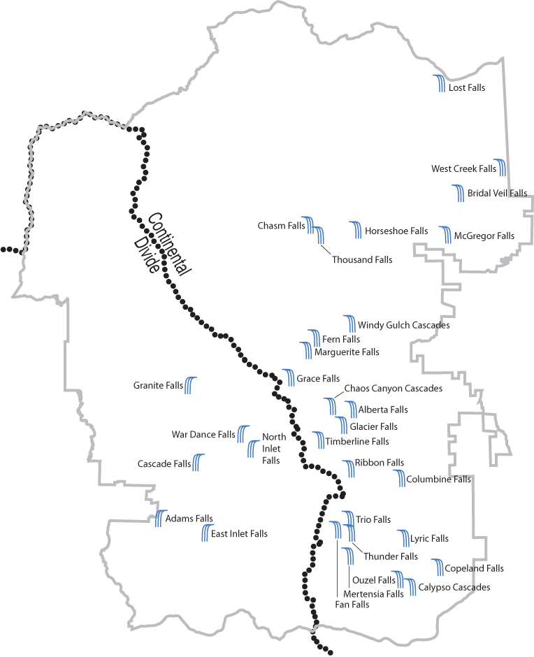
Map of the Falls in the Park
| Name | Lat | Lon | Height (feet) | Elevation |
| Adams Falls | 40.2368 | -105.7960 | 55 | 8,505 |
| Alberta Falls | 40.3034 | -105.6375 | 25 | 9,400 |
| Bridal Veil Falls | 40.4358 | -105.5503 | 40 | 8,840 |
| Calypso Cascades | 40.1942 | -105.5900 | 90 | 9,280 |
| Cascade Falls | 40.2711 | -105.7656 | ? | 8,795 |
| Chaos Canyon Cascades | 40.3054 | -105.6544 | ? | 10,000 |
| Chasm Falls | 40.4167 | -105.6721 | 30 | 9,050 |
| Columbine Falls | 40.2611 | -105.5986 | 110 | 11,440 |
| Copeland Falls | 40.2062 | -105.5678 | 12 | 8,510 |
| East Inlet Falls | 40.2280 | -105.7583 | ? | 8,960 |
| Fan Falls | 40.2295 | -105.6504 | ? | 11,160 |
| Fern Falls | 40.3474 | -105.6672 | 60 | 8,800 |
| Glacier Falls | 40.2938 | -105.6453 | 12 | 9,870 |
| Grace Falls | 40.3231 | -105.6881 | ? | 10,265 |
| Granite Falls | 40.3185 | -105.7717 | ? | 9,805 |
| Horseshoe Falls | 40.4137 | -105.6335 | 250 | 8,900 |
| Lost Falls | 40.5035 | -105.5655 | ? | 9,850 |
| "Lost Brook Falls" | 40.3671 | -105.6976 | 40 | 9,440 |
| Lyric Falls | 40.2242 | -105.5954 | ? | 10,150 |
| Marguerite Falls | 40.3398 | -105.6740 | ? | 9,430 |
| MacGregor Falls | 40.4106 | -105.5609 | 20 | 8,405 |
| Mertensia Falls | 40.2128 | -105.6406 | ? | 10,370 |
| North Inlet Falls | 40.2791 | -105.7207 | ? | 9,490 |
| Ouzel Falls | 40.1990 | -105.6002 | 60 | 9,460 |
| Ribbon Falls | 40.2669 | -105.6396 | ? | 10,565 |
| Thousand Falls | 40.4106 | -105.6638 | ? | 9,200 |
| Thunder Falls | 40.2275 | -105.6393 | ? | 10,895 |
| Timberline Falls | 40.2846 | -105.6639 | 30 | 10,475 |
| Trio Falls | 40.2359 | -105.6400 | ? | 11,285 |
| War Dance Falls | 40.2885 | -105.7292 | ? | 9,900 |
| West Creek Falls | 40.4513 | -105.5164 | 22 | 7,955 |
| Windy Gulch Cascades | 40.3557 | -105.6385 | ? | 8,700 |
The height of the falls is an estimate, and in the cases of falls with multiple drops, is the sum height of the entire falls.
The elevations of the falls are estimated at their center point from USGS Topographic maps and may not be their official elevations.
Quad information to come later
Map of the Falls in the Park